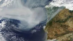
Smoke from wildfires in Canada Crossed the Atlantic Ocean and reached southwestern Europe. An image from NASA’s Terra satellite taken Monday morning shows the flow over northern Portugal and Spain.
Beyond Image’s scope, the company said it has expanded northward to other European countries. The satellite used its Medium Resolution Imaging Spectroradiometer to capture the image.
Smoke from the wildfires has smothered cities southeast of New York, with 120 million under a sky-level warning.
For weeks, smoke from wildfires in the Canadian province of Quebec crossed the Atlantic Ocean and reached southwestern Europe. This image was taken by NASA’s Terra satellite on Monday morning. (NASA Earth Observatory)
Black carbon particles, also known as soot, traveled more than 2,000 miles.
The black carbon concentration data shared by NASA comes from its Goddard Earth Observing System forward processing model. The model integrates data from satellite, aircraft and ground-based observing systems, as well as meteorological data – such as air temperature, humidity and wind to project plume behavior.
The vast reach of the smoke, stretching for thousands of miles, is evident on the NASA map. (NASA Earth Observatory)
Smog skies are also monitored by a network of ground sensors called the Aerosols Robotic Network.
The network, known as AERONET, consists of more than 500 sun photometer instruments that measure global aerosol optical depth.
Sensors in Spain and France saw depth measurements greater than 0.5. Typically, the magnitude in this region is close to 0.1, with a completely clear sky having a magnitude of less than 0.05.